
How the AER calculates VRR
And net pay for three cycles
 There may be differences in the way the AER calculates VRR from what you would expect. Knowing these can help you in your compliance negotiations with them. VRR calculation nuances are a source of discussion in this application.
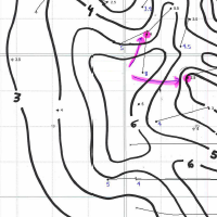
This applicant also showed offsets his net pay maps when he put it in the public domain. Each of three cycles is shown. Any geological or geophysical data you add to an AER application is in the public domain the minute you apply.
There may be differences in the way the AER calculates VRR from what you would expect. Knowing these can help you in your compliance negotiations with them. VRR calculation nuances are a source of discussion in this application.
This applicant also showed offsets his net pay maps when he put it in the public domain. Each of three cycles is shown. Any geological or geophysical data you add to an AER application is in the public domain the minute you apply.
Each AER application contains your neighbor's perspective on the exploitation of oil and gas formations. Applications contain more technical data even than SPE papers.
Would you like to see what other operators in your areas are thinking about seismic, multifractured wells, polymer schemes and recovery? AppIntel can help.
Subscribers can view this application by pasting the following link into their browser after logging into AppIntel. http://app.appintel.info/AOW.php?pxnrg=45787o32333531313834325141
Tags: Flood, Exploration
 Granger Low 3 Nov 2015


Flowback water has a second life
Frack water is too expensive to waste

9 potent ways to enhance steam injection: SAGD
Methane, propane, solvent or surfactant?

Let AppIntel AI watch this CO2 dispute for you
19 new developments today

Polymer floods fashionable again
Check out your competitor's polymer pad sizes and concentrations
 Calgary, Alberta, Canada
 Share
Share