
Undrilled offsetting acreage
Net pay and structure maps included
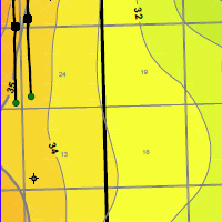 Net pay mapping of undrilled acreage is shown when this applicant placed his net pay map in the public domain. Structure mapping and cross sections are also included. Any geological or geophysical data you add to an AER application is in the public domain the minute you apply. Always use any contour options available to map your pool onto your own land. Otherwise you may encourage someone to put another straw in your pool. The service that submitted this application should have known better. We found this using AppIntel.
Each AER application contains your neighbor's perspective on the exploitation of oil and gas formations. Applications contain more technical data even than SPE papers.
Would you like to see what other operators in your areas are thinking about seismic, multifractured wells, polymer schemes and recovery? AppIntel can help.
Subscribers can view this application by pasting the following link into their browser after logging into AppIntel. app.appintel.info/AOW.php?pxnrg=58596n383338373631313o4n78
Tags: Flood, Exploration
 Granger Low 2 Dec 2015


Give us more flexibility in thermal schemes!
Reducing thermal heavy oil scheme red tape

ER schemes are hot right now. Here's the catch.
Cheap capital, fast reserves – but only if you get it right

Sequestering CO2 may disrupt nearby salt caverns?
Prompts conflict between operators

Breathing life into SAGD
Air injection as well as steam
 Calgary, Alberta, Canada
 Share
Share