
Free drilling location shown in public domain
This applicant gave away a free corner shot location offsetting his pool.
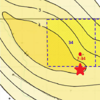 This applicant gave away a free corner shot location offsetting his pool when we placed his net pay map in the public domain. Any geological or geophysical data you add to an AER application is in the public domain the minute you apply.
Always use any contour options available to map your pool onto your own land. Otherwise you may encourage someone to put another straw in your pool. The service that submitted this application should have known better. AppIntel can help you find these opportunities.
You can help yourself to his mapping other application documents by visiting our secure website. Just click the button below.
Get details of this cool tech Subscribers get them for free?subject=Show me how to find corner shots in my neighbor's net pay maps.&body=Sign me up for an AppIntel subscription so I can find corner shots in my neighbor's net pay maps. %0D%0A%0D%0AMy Name:__________ %0D%0AMy Phone Number:__________ %0D%0A%0D%0A(Or call Proven Sales at 403-803-2500.)">Contact us to find out how through AppIntel.
However you might not want to drill this one -- the geologist made it look like a lemon.
Each AER application contains your neighbor's perspective on the exploitation of oil and gas formations. AppIntel can help you find them.
Tags: Exploration
 Granger Low 25 May 2015


Give us more flexibility in thermal schemes!
Reducing thermal heavy oil scheme red tape

ER schemes are hot right now. Here's the catch.
Cheap capital, fast reserves – but only if you get it right

Sequestering CO2 may disrupt nearby salt caverns?
Prompts conflict between operators

Breathing life into SAGD
Air injection as well as steam
 Calgary, Alberta, Canada
 Share
Share