
Edge shot from AER application maps
He unwittingly showed them
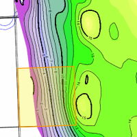 While applying for an modification to a mature water flood, this operator gave away several edge shots. His mapping has changed since the unit was struck many years ago. New mapping shows opportunities at the edge of his unit. He unwittingly showed these opportunities in mapping that he included in his routine water flood application. We found this using AppIntel.
Any geological or geophysical data you add to an AER application is in the public domain the minute you apply. Always use any contour options available to map your pool onto your own land. Otherwise you may encourage someone to put another straw in your pool.
Each AER application contains your neighbor's perspective on the exploitation of oil and gas formations. Applications contain more technical data even than CSPG papers.
Would you like to see what other operators in your areas are thinking about seismic, multifractured wells, polymer schemes and recovery? AppIntel can help.
Subscribers can view this application by pasting the following link into their browser after logging into AppIntel. app.appintel.info/AOW.php?pxnrg=48776y35323635313138355531
Tags: Flood, Exploration
 Granger Low 1 Mar 2016


Give us more flexibility in thermal schemes!
Reducing thermal heavy oil scheme red tape

ER schemes are hot right now. Here's the catch.
Cheap capital, fast reserves – but only if you get it right

Sequestering CO2 may disrupt nearby salt caverns?
Prompts conflict between operators

Breathing life into SAGD
Air injection as well as steam

Injecting steam and flue gas into heavy oil
Capture Carbon. Improve Recovery.
 Calgary, Alberta, Canada
 Share
Share